logo
freizeitwetter .info
Impressum Nutzungsbedingungen Attributions

© Schulkreis.de e.K.
Freizeitwetter.info Version 3.5.4

Alle Angaben ohne Gewähr. Daten nur zu Demozwecken verwenden!

US-1844

Cheryl-Lane Landings Airport


0 km/h
Flugplatzdetails
Wetterinfo- -
Koordinaten28.6711W 82.0873E
TypSmall airport
LandUnited States (Vereinigte Staaten von Amerika) weitere Länder...
Gehört zuBushnell
Orte in der Nähe Bushnell, Center Hill, Lake Panasoffkee, Ridge Manor, Wildwood, Mascotte, Floral City, Hawthorne, Lacoochee, Leesburg,
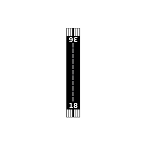
Landebahnen 18/36
Fluginformation (FIR)Jacksonville
Umgebungskarte Cheryl-Lane Landings Airport

Anflug-Informationen

Klicke den Kompass an, um die Landebahn in Position zu drehen.
0 km/h

Landebahn-Informationen

Liste der verfügbaren Landebahnen, vermutlich aktive Piste hervorgehoben.
Runway RWY-Richtung Seitenwind Gegenwind
18/36 180°/0° - -

Wettervorhersage (DWD)

Station:
Keine Wetterdaten vorhanden.

Flugplätze in der Nähe

Flying W Airranch Airport 7 km - -
Croom A Chobee Airport 7 km - -
Nr3 Farms Airport 8 km - -
Connells Wahoo Airport 8 km - -
Ko-Kee Airport 10 km - -
Montgomery's Flying M Ranch Airport 12 km - -
Grass Patch Airport 13 km - -
Lake Panasoffkee Seaplane Base 15 km - -
Central Florida Airpark 16 km - -
Tex Merritt Private Airstrip Airport 17 km - -
Grass Roots Airpark 20 km - -
Flying Baron Estates Airport 20 km - -
Rutland Runway Airport 24 km - -
Kennedy Seaplane Base 24 km - -
Foxraven Field 25 km - -
Ranchaero Grand Vista Airport 26 km - -
Osborn Airfield 26 km - -
Field Of Dreams 27 km - -
KINF Inverness Airport 27 km METAR TAF
Two J'S Flying Ranch Airport 27 km - -
Flying Palomino Ranch Airport 27 km - -
Cub Haven Airport 27 km - -
Sheets Airport 28 km - -
Chinsegut Airport 28 km - -
Flying-H Airport 30 km - -
Dusty Airpatch Airport 32 km - -
KLEE Leesburg International Airport 32 km METAR TAF
S & S Avion Ranch Airport 32 km - -
Silver Lake Seaplane Base 33 km - -
Kings Field 33 km - -
Tarvair Seaplane Base 33 km - -
Searey Central Seaplane Base 35 km - -
Kiever Airport 37 km - -
Love Field 38 km - -
Hobby Hill Airport 38 km - -
Tavares Seaplane Base 38 km - -
Seminole Lake Gliderport 38 km - -
Monroe Airpark 39 km - -
Jordan Seaplane Base 40 km - -
Johary Airport 41 km - -
Sierra Airpark 41 km - -
McGinley Airport 41 km - -
KBKV Brooksville-Tampa Bay Regional Airport 42 km METAR TAF
Orlando North Airpark 43 km - -
Drake Ranch Airport 43 km - -
Rockin G Ranch Airport 43 km - -
Twelve Oaks Airport 44 km - -
Orlando Seaplane Base 44 km - -
Jones Brothers East Seaplane Base 45 km - -
Bob White Field 45 km - -
Back Achers Airport 46 km - -
Briley Farm Seaplane Base 46 km - -
Burntwood Ranch Airport 47 km - -
Leeward Air Ranch Airport 47 km - -
Tangerine Airport 48 km - -
Shady International Airport 48 km - -
Seven Feathers Airport 48 km - -
Mid-Florida Airport 49 km - -
Lake Apopka South Seaplane Base 49 km - -
Orlando Apopka Airport 49 km - -
KZPH Zephyrhills Municipal Airport 50 km METAR TAF
Post Oak Ranch Airport 50 km - -
Alle Angaben ohne Gewähr. Daten nur zu Demozwecken verwenden!