logo
freizeitwetter .info
Impressum Nutzungsbedingungen Attributions

© Schulkreis.de e.K.
Freizeitwetter.info Version 3.5.4

Alle Angaben ohne Gewähr. Daten nur zu Demozwecken verwenden!

12°C
6°C
15°C

KDOV

Dover Air Force Base


0 km/h
Flugplatzdetails
WetterinfoMETAR TAF
Koordinaten39.1297W 75.4657E
TypMidsized airport
LandUnited States (Vereinigte Staaten von Amerika) weitere Länder...
Gehört zuDover
Orte in der Nähe Dover Base Housing, Rising Sun-Lebanon, Highland Acres, Kent Acres, Rodney Village, Dover, Camden, Wyoming, Woodside East, Riverview,
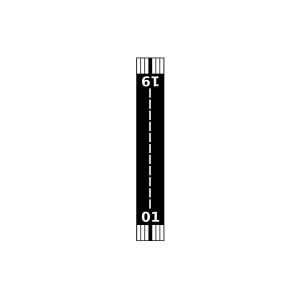
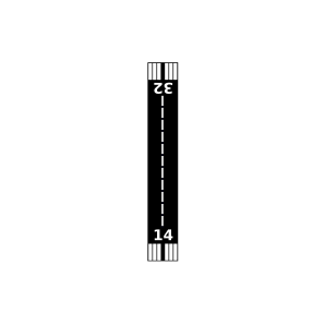
Landebahnen 01/19, 14/32
Fluginformation (FIR)Washington
Umgebungskarte Dover Air Force Base

Anflug-Informationen

Klicke den Kompass an, um die Landebahn in Position zu drehen.
0 km/h

Landebahn-Informationen

Liste der verfügbaren Landebahnen, vermutlich aktive Piste hervorgehoben.
Runway RWY-Richtung Seitenwind Gegenwind
01/19 3°/183° - -
14/32 126°/306° - -

Wettervorhersage (DWD)

Station:
Keine Wetterdaten vorhanden.

Flugplätze in der Nähe

Johnsons Airport 7 km - -
Chandelle Airport 8 km - -
Jenkins Airport 10 km - -
Albanna Aviation Airport 14 km - -
Delaware Airpark 15 km - -
Doyle's Airport 15 km - -
Belfair Airport 22 km - -
Smyrna Airport 22 km - -
Hrupsa Airport 23 km - -
Our Domain Airport 24 km - -
Murphy's Landing Airport 26 km - -
Taylor Field 29 km - -
Full Throttle Farm Airport 30 km - -
Dave's Aerodrome Airport 31 km - -
Scotty's Place Airport 31 km - -
Halka Nurseries Airport 31 km - -
Spiering Airport 32 km - -
Willaview Airport 32 km - -
Whalen Field 33 km - -
Chorman Airport 34 km - -
Hidden Acres Farm Airport 34 km - -
Massey Aerodrome Airport 34 km - -
D'Angelo Airport 35 km - -
Townsend A Airport 36 km - -
Roseland Airport 36 km - -
Spirit Airpark 36 km - -
G W Farm Airport 36 km - -
Myles Landing Airport 37 km - -
Wide Sky Airpark 38 km - -
Flying Acres Airport 39 km - -
KRJD Gooden Airpark 39 km METAR TAF
Stoe Creek Farm Airport 39 km - -
Taildragger Acres Airport 40 km - -
Sugar Hill Airport 40 km - -
Woodcrest Farms Airstrip Airport 41 km - -
KMIV Millville Municipal Airport 43 km METAR TAF
Ockel Farms Airport 43 km - -
Huey Airport 43 km - -
Eagle Crest-Hudson Airport 44 km - -
Bucks Airport 45 km - -
Mckeown Airport 47 km - -
Hexton Farms Airport 47 km - -
Saxon Farms Airport 48 km - -
Salem Airfield 48 km - -
Slater Field 48 km - -
Paramount Air Airport 49 km - -
Blews Airport 49 km - -
KEVY Summit Airport 49 km METAR TAF
Hybarc Farm Airport 49 km - -
Cromwell Farm Airport 50 km - -
Kennersley Airport 50 km - -
KWWD Cape May County Airport 50 km METAR TAF
Alle Angaben ohne Gewähr. Daten nur zu Demozwecken verwenden!