logo
freizeitwetter .info
Impressum Nutzungsbedingungen Attributions

© Schulkreis.de e.K.
Freizeitwetter.info Version 3.5.4

Alle Angaben ohne Gewähr. Daten nur zu Demozwecken verwenden!

US-3548

Woodlake Landing Airport


0 km/h
Flugplatzdetails
Wetterinfo- -
Koordinaten41.6384W 88.6445E
TypSmall airport
LandUnited States (Vereinigte Staaten von Amerika) weitere Länder...
Gehört zuSandwich
Orte in der Nähe Sandwich, Somonauk, Lake Holiday, Plano, Newark, Sheridan, Hinckley, Big Rock, Yorkville, Waterman,
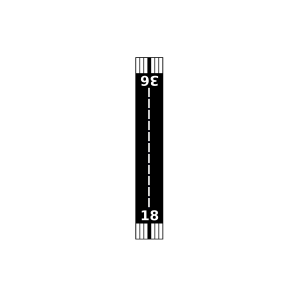
Landebahnen 08/26, 18/36
Fluginformation (FIR)Chicago
Umgebungskarte Woodlake Landing Airport

Anflug-Informationen

Klicke den Kompass an, um die Landebahn in Position zu drehen.
0 km/h

Landebahn-Informationen

Liste der verfügbaren Landebahnen, vermutlich aktive Piste hervorgehoben.
Runway RWY-Richtung Seitenwind Gegenwind
08/26 80°/260° - -
18/36 180°/0° - -

Wettervorhersage (DWD)

Station:
Keine Wetterdaten vorhanden.

Flugplätze in der Nähe

Walnut Creek Airport 6 km - -
Gord Airport 7 km - -
George Airport 8 km - -
Cwian Field 11 km - -
Cushing Field LTD. 14 km - -
Hinckley Airport 16 km - -
Wade Airport 17 km - -
J Maddock Airport 17 km - -
Friends Field 18 km - -
Humm Airport 19 km - -
Vogen Airport 20 km - -
KARR Aurora Municipal Airport 20 km METAR TAF
Cody Port Airport 21 km - -
Oakfield 24 km - -
Marshall Farms Airport 25 km - -
Nettle Creek Landings Airport 25 km - -
Jack W Watson Airport 27 km - -
B & C Airport 27 km - -
Skydive Chicago Airport 29 km - -
Morris Municipal/James R Washburn Field 30 km - -
David Gillespie Airport 30 km - -
Ruffatto Field 31 km - -
Mitchell Airport 31 km - -
Younglove/Otterbach Airport 32 km - -
Ruder Airport 32 km - -
KDKB De Kalb Taylor Municipal Airport 33 km METAR TAF
Dunn Airport 33 km - -
Uncle Chuck's Airport 33 km - -
Bushby Airport 34 km - -
Durin Airport 36 km - -
Spring Brook Airport 38 km - -
Naper Aero Club Airport 38 km - -
Hep Cats Airport 38 km - -
Earl Barnickel Airport 39 km - -
W Davis Airport 40 km - -
Chicago Glider Club 40 km - -
Willadae Farms Airport 40 km - -
Bresson Airport 40 km - -
Colonial Acres Airport 41 km - -
Hendrickson Flying Service Airport 41 km - -
KJOT Joliet Regional Airport 41 km METAR TAF
Grandpa's Farm Mendota Airport 43 km - -
Ranken Airport 43 km - -
Bolingbrook's Clow International Airport 43 km - -
Harford Airport 44 km - -
Staton Airport 44 km - -
Olson Airport 44 km - -
Curanda Airport 45 km - -
KDPA Dupage Airport 45 km METAR TAF
Otterbach Farm Airport 45 km - -
Delhotal Airport 45 km - -
KLOT Lewis University Airport 46 km METAR TAF
KRPJ Rochelle Municipal/Koritz Field 46 km METAR TAF
Flaherty Field 47 km - -
7TH Heaven Airport 48 km - -
Harold Bunger Airport 48 km - -
Hope Field 48 km - -
Vodden Airport 49 km - -
Aero Lake Estates Airport 49 km - -
Alle Angaben ohne Gewähr. Daten nur zu Demozwecken verwenden!